Difference between revisions of "Wellge map"
m |
m (→Details) |
||
| (8 intermediate revisions by 2 users not shown) | |||
| Line 8: | Line 8: | ||
==Details== | ==Details== | ||
<!-- NOTE... I am going to add some content in here soon --> | <!-- NOTE... I am going to add some content in here soon --> | ||
| − | :''See also the [[:Image:WellgeMapHR.jpg|high-resolution version]].'' | + | :''Points of interest transcribed as written. See also the [[:Image:WellgeMapHR.jpg|high-resolution version]].'' |
<gallery> | <gallery> | ||
| − | Image:WellgeA.jpg|A. [[First United Methodist Church|Methodist [Church] ]]. | + | Image:WellgeA.jpg|A. [[First United Methodist Church|Methodist [Church]]]. |
| − | Image:WellgeC.jpg|C. [[St. Michael's Church|Catholic [Church] ]]. | + | Image:WellgeB.jpg|B. [[First Baptist Church|Baptist [Church]]]. |
| + | Image:WellgeC.jpg|C. [[St. Michael's Church|Catholic [Church]]]. | ||
| + | Image:WellgeD.jpg|D. Presbyterian [Church]. | ||
| + | Image:WellgeE.jpg|E. [[Old Christ Church|Episcopal [Church]]]. | ||
Image:WellgeF.jpg|F. [[Temple Beth-El|Jewish Synagogue]]. | Image:WellgeF.jpg|F. [[Temple Beth-El|Jewish Synagogue]]. | ||
| − | Image:WellgeH.jpg|H. Colored Methodist [Church]. | + | Image:WellgeG.jpg|G. [[St. John the Baptist Church|Colored Baptist [Church]]]. |
| − | Image:Wellge2.jpg|2. [[ | + | Image:WellgeH.jpg|H. [[African Methodist Episcopal Zion Church|Colored Methodist [Church]]]. |
| − | Image:Wellge3.jpg|3. [[Escambia County Courthouse|County Court House]]. | + | Image:Wellge2.jpg|2. [[U.S. Custom House, Court House and Post Office]]. |
| − | Image:Wellge6.jpg|6. School House. | + | Image:Wellge3.jpg|3. [[Old Escambia County Courthouse|County Court House]]. |
| + | Image:Wellge4.jpg|4. [[Old Escambia County Jail|County Jail]]. | ||
| + | Image:Wellge5and15.jpg|5. [[Pensacola Opera House|Opera House]]. | ||
| + | Image:Wellge6.jpg|6. [[High School No. 1|School House]]. | ||
| + | Image:Wellge7.jpg|7. Marine Hospital. | ||
Image:Wellge8.jpg|8. [[Osceola Club]] Building. | Image:Wellge8.jpg|8. [[Osceola Club]] Building. | ||
| − | Image:Wellge9.jpg|9. [[ | + | Image:Wellge9.jpg|9. [[Union Depot|L. & N. and P. & A. R. R. Passenger Depot]]. |
| + | Image:Wellge10.jpg|10. [[Roundhouse|Round House]] and Shops. | ||
Image:Wellge12.jpg|12. Gulf Ice Co.'s Ice Mfg. | Image:Wellge12.jpg|12. Gulf Ice Co.'s Ice Mfg. | ||
| − | Image:Wellge14and18.jpg|14. Merchants Bank, [[Louis P. Knowles]], Prest., [[E. W. Menefee]], Cash. | + | Image:Wellge13.jpg|13. [[Clubbs Block|Clubb's Block]], [[A. V. Clubbs|A. V. Clubb's]]. |
| − | Image:Wellge17.jpg|17. [[New Continental Hotel]], [[D. K. Hickey]], prop. | + | Image:Wellge14and18.jpg|14. [[Merchants Bank]], [[Louis P. Knowles]], Prest., [[E. W. Menefee]], Cash. |
| + | Image:Wellge5and15.jpg|15. [[First National Bank]], [[M. H. Sullivan]], Prest., [[W. A. S. Wheeler]], Cash. | ||
| + | Image:Wellge16.jpg|16. Brents Bank, [[F. C. Brent]]. | ||
| + | Image:Wellge17.jpg|17. [[New Continental Hotel]], [[D. K. Hickey]], prop. also proprietor. of the Chautauqua Hotel Lake, De Funiak, 80 Miles East of Pensacola. | ||
Image:Wellge14and18.jpg|18. [[Merchants' Hotel|Merchants Hotel]]. M. Kryger, Prop. | Image:Wellge14and18.jpg|18. [[Merchants' Hotel|Merchants Hotel]]. M. Kryger, Prop. | ||
| + | Image:Wellge19.jpg|[[City Hotel]], [[Edward Sexauer|Ed. Sexauer]], Prop. | ||
| + | Image:Wellge20.jpg|[[Commercial Hotel]]. | ||
Image:Wellge21.jpg|21. Carriage Manufactory, Harvey & Hilliard. | Image:Wellge21.jpg|21. Carriage Manufactory, Harvey & Hilliard. | ||
| + | Image:Wellge22.jpg|Lumber and Timber Mill, [[George Washington Wright|Geo. W. Wright]]. | ||
| + | Image:Wellge23.jpg|23. Planing Mill, Sash, Doors and Blind Mfg. [[C. H. Overman]] & Co. | ||
| + | Image:Wellge24.jpg|24. [[Pensacola Foundry]], [[J. Cosgrove]]. | ||
| + | Image:Wellge25.jpg|25. Golay Mills, [[M. F. Gonzalez]]. | ||
| + | Image:Wellge26.jpg|26. Livery Feed & Sale Stable, [[J. B. Roberts|J. B. Robert's]] & Son. | ||
</gallery> | </gallery> | ||
| − | |||
| − | |||
| − | |||
| − | |||
| − | |||
| − | |||
| − | |||
| − | |||
| − | |||
| − | |||
| − | |||
| − | |||
| − | |||
| − | |||
| − | |||
| − | |||
| − | |||
| − | |||
| − | |||
| − | |||
| − | |||
| − | |||
| − | |||
| − | |||
| − | |||
| − | |||
| − | |||
| − | |||
| − | |||
| − | |||
| − | |||
| − | |||
| − | |||
| − | |||
| − | |||
| − | |||
| − | |||
| − | |||
| − | |||
| − | |||
| − | |||
==Directory== | ==Directory== | ||
| Line 72: | Line 49: | ||
==Notes== | ==Notes== | ||
| − | + | *The map is not to scale and contains numerous spelling and consistency errors. | |
| + | *[[Belmont Street]] becomes '''1st Street''' east of [[Hayne Street|Hayne]], north of which all the streets are numbered. (For example, [[Cervantes Street]] is shown as '''5th Street'''. | ||
| + | *[[Chase Street]] west of [[Reus Street|Reus]] is labeled '''Havanna Street'''. | ||
| + | *[[Main Street]] is interrupted at [[Baylen Street]]; a smaller road continues westward and bridges a small inlet. | ||
==References== | ==References== | ||
*[http://memory.loc.gov/cgi-bin/query/D?gmd:22:./temp/~ammem_9Rr9::@@@mdb=mcc,gottscho,detr,nfor,wpa,aap,cwar,bbpix,cowellbib,calbkbib,consrvbib,bdsbib,dag,fsaall,gmd,pan,vv,presp,varstg,suffrg,nawbib,horyd,wtc,toddbib,mgw,ncr,ngp,musdibib,hlaw,papr,lhbumbib,rbpebib,lbcoll,alad,hh,aaodyssey,magbell,bbcards,dcm,raelbib,runyon,dukesm,lomaxbib,mtj,gottlieb,aep,qlt,coolbib,fpnas,aasm,scsm,denn,relpet,amss,aaeo,mffbib,afc911bib,mjm,mnwp,rbcmillerbib,molden,ww2map,mfdipbib,afcnyebib,hawp,omhbib,rbaapcbib,mal,ncpsbib,ncpm,lhbprbib,ftvbib,afcreed,aipn,cwband,flwpabib,wpapos,cmns,psbib,pin,coplandbib,cola,tccc,curt,mharendt,lhbcbbib,eaa,haybib,mesnbib,fine,cwnyhs,svybib,mmorse,afcwwgbib,mymhiwebib,uncall,afcwip,mtaft,manz,llstbib,fawbib,berl,fmuever,cdn,upboverbib,mussm,cic,afcpearl,awh,awhbib,sgp,wright,lhbtnbib,afcesnbib,hurstonbib,mreynoldsbib,spaldingbib,sgproto Library of Congress - American Memory] | *[http://memory.loc.gov/cgi-bin/query/D?gmd:22:./temp/~ammem_9Rr9::@@@mdb=mcc,gottscho,detr,nfor,wpa,aap,cwar,bbpix,cowellbib,calbkbib,consrvbib,bdsbib,dag,fsaall,gmd,pan,vv,presp,varstg,suffrg,nawbib,horyd,wtc,toddbib,mgw,ncr,ngp,musdibib,hlaw,papr,lhbumbib,rbpebib,lbcoll,alad,hh,aaodyssey,magbell,bbcards,dcm,raelbib,runyon,dukesm,lomaxbib,mtj,gottlieb,aep,qlt,coolbib,fpnas,aasm,scsm,denn,relpet,amss,aaeo,mffbib,afc911bib,mjm,mnwp,rbcmillerbib,molden,ww2map,mfdipbib,afcnyebib,hawp,omhbib,rbaapcbib,mal,ncpsbib,ncpm,lhbprbib,ftvbib,afcreed,aipn,cwband,flwpabib,wpapos,cmns,psbib,pin,coplandbib,cola,tccc,curt,mharendt,lhbcbbib,eaa,haybib,mesnbib,fine,cwnyhs,svybib,mmorse,afcwwgbib,mymhiwebib,uncall,afcwip,mtaft,manz,llstbib,fawbib,berl,fmuever,cdn,upboverbib,mussm,cic,afcpearl,awh,awhbib,sgp,wright,lhbtnbib,afcesnbib,hurstonbib,mreynoldsbib,spaldingbib,sgproto Library of Congress - American Memory] | ||
*[http://www.askart.com/askart/w/henry_wellge/henry_wellge.aspx AskART] | *[http://www.askart.com/askart/w/henry_wellge/henry_wellge.aspx AskART] | ||
| − | |||
| − | |||
[[Category:Maps]] | [[Category:Maps]] | ||
Latest revision as of 19:28, 2 October 2008

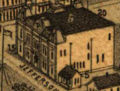
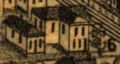
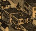
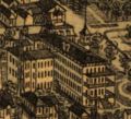
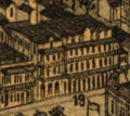
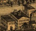
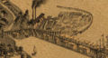
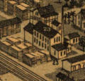
The Wellge map is an aerial rendering of Pensacola created in 1885 by Henry Wellge. The extremely detailed lithograph is a bird's eye perspective of downtown Pensacola, then a bustling port city.
A legend, directory and numbered points of interest line the bottom, along with inset illustrations of three locations: the New Continental Hotel, the Navy Yards and the Merchants' Hotel.
The map was published by Norris, Wellge & Co. of Milwaukee, Wisconsin. Wellge toured across the continent and created similar renderings for more than 150 cities.
Contents
Details[edit]
- Points of interest transcribed as written. See also the high-resolution version.
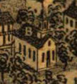
B. Baptist [Church].
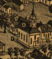
D. Presbyterian [Church].
F. Jewish Synagogue.
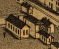
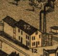
4. County Jail.
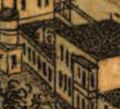
5. Opera House.
6. School House.
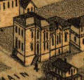
- Wellge7.jpg
7. Marine Hospital.
8. Osceola Club Building.
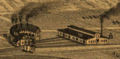
10. Round House and Shops.
12. Gulf Ice Co.'s Ice Mfg.
13. Clubb's Block, A. V. Clubb's.
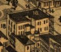
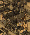
14. Merchants Bank, Louis P. Knowles, Prest., E. W. Menefee, Cash.
15. First National Bank, M. H. Sullivan, Prest., W. A. S. Wheeler, Cash.
16. Brents Bank, F. C. Brent.
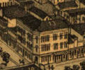
17. New Continental Hotel, D. K. Hickey, prop. also proprietor. of the Chautauqua Hotel Lake, De Funiak, 80 Miles East of Pensacola.
18. Merchants Hotel. M. Kryger, Prop.
City Hotel, Ed. Sexauer, Prop.
21. Carriage Manufactory, Harvey & Hilliard.
Lumber and Timber Mill, Geo. W. Wright.
23. Planing Mill, Sash, Doors and Blind Mfg. C. H. Overman & Co.
24. Pensacola Foundry, J. Cosgrove.
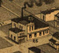
25. Golay Mills, M. F. Gonzalez.
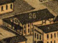
26. Livery Feed & Sale Stable, J. B. Robert's & Son.


Directory[edit]
| This section is a stub. You can help by expanding it. |
Notes[edit]
- The map is not to scale and contains numerous spelling and consistency errors.
- Belmont Street becomes 1st Street east of Hayne, north of which all the streets are numbered. (For example, Cervantes Street is shown as 5th Street.
- Chase Street west of Reus is labeled Havanna Street.
- Main Street is interrupted at Baylen Street; a smaller road continues westward and bridges a small inlet.