Garden Street
| |||
| Garden Street | |||
| west end: | Pace Boulevard (Florida 292) | ||
|---|---|---|---|
| Major junctions: |
Barrancas Avenue/D Street A Street Spring Street Baylen Street Palafox Street Jefferson Street Tarragona Street | ||
| east end: | Alcaniz Street | ||


Garden Street is a major east-west thoroughfare in downtown Pensacola. It serves as the original dividing line for the city's north-south streets.
Garden Street's western terminus is at Pace Boulevard in West Pensacola; west of that intersection the roadway continues as Navy Boulevard. Garden Street travels east from Pace Boulevard into the heart of downtown Pensacola and terminates at Alcaniz Street near St. Michael's Cemetery. For the entirety of its length Garden Street carries US 98 Business. Garden Street is four-laned for its entirety, however, between A Street and Alcaniz Street its east and west spans are separated by a median.
Historically, there was an incontiguous span of Garden that ran from Cevallos to 12th Avenue at the bay.[1]
Name[edit]
Under the British city plan drawn up around 1764 by Elias Durnford, each individual building lot in the city was issued a companion piece of ground along what was then the northern border of the town. The thoroughfare which developed along this row of garden lots was fittingly called Garden Street:
| The lots south of Garden street had an area of 80 feet front and 170 in depth. North of that street they were 192 feet square, known as arpent or Garden lots, and numbered to correspond with those lying south of Garden street, which were, strictly speaking, town lots. In order to furnish each family with a garden spot, each grantee of a town lot was entitled, upon the condition of improvement, to receive a conveyance of an arpent lot of the same number as his town lot. | ||
—Campbell, Richard L. "Historical Sketches of Colonial Florida". The Williams Publishing Co., Cleveland: 1892. | ||
A 1950 ordinance designated the portion of Garden Street west of Barrancas Avenue as Navy Boulevard; this was later amended to cover only west of Pace Boulevard.[2]
Images[edit]
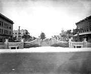
Looking west at Palafox, c. 1908
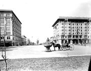
A horse-watering fountain, given by Dr. Blocker, was later moved to the downtown post office


Notes & references[edit]
- ↑ As of 1907 Sanborn Fire Map
- ↑ Ordinance #24-50, City of Pensacola