Difference between revisions of "Pintado plan"
(New page: thumb|right|''Plano, Panzacola, 1812'' The '''Pintado plan''' is a street map drawn by Vicente Sebastián Pintado in 1812. It was published the foll...) |
|||
| Line 1: | Line 1: | ||
| − | [[Image:Plan1812-halfres.jpg|thumb|right| | + | [[Image:Plan1812-halfres.jpg|thumb|right|The Pintado plan]] |
| − | The '''Pintado plan''' is a street map drawn by [[Vicente Sebastián Pintado]] | + | The '''Pintado plan''' is a street map drawn in [[1812]] by [[Vicente Sebastián Pintado]], Surveyor General of [[Spanish West Florida]]. |
| + | |||
| + | The very lengthy but full title of the map is | ||
| + | :''Borrador del nuevo proyecto para el arreglo de dos plazas en la Poblacion de Panzacola á los extremos oriental y occidental de la actual determinacion de la extension de cada una y la posicion y dimensiones de los Solares para fabricar el Templo y otros Edificios publicos''. | ||
The map depicts the street grid in the core old city of Pensacola; most of the grid and street names depicted are still intact today. Among the streets named on the Pintado plan are: | The map depicts the street grid in the core old city of Pensacola; most of the grid and street names depicted are still intact today. Among the streets named on the Pintado plan are: | ||
| Line 16: | Line 19: | ||
What is now [[Zaragoza Street]] is not contiguous on the Pintado plan, but rather split among streets labelled "Calle de la Recova" and "Calle del Tivoli de Reding". The shoreline is depicted near where present-day [[Main Street]] would be. | What is now [[Zaragoza Street]] is not contiguous on the Pintado plan, but rather split among streets labelled "Calle de la Recova" and "Calle del Tivoli de Reding". The shoreline is depicted near where present-day [[Main Street]] would be. | ||
| − | Confusingly, what is now [[Seville Square]] is depicted as "Plaza de Fernando 7<sup> | + | Confusingly, what is now [[Seville Square]] is depicted as "Plaza de Fernando 7<sup>o</sup>" (Plaza of Ferdinand VII), while the [[Plaza Ferdinand VII|plaza to the west that currently bears that name]] is called "Plaza de la Constitución" (Constitution Plaza). |
| + | |||
| + | The map itself is held in the collections of the [[Wikipedia:George A. Smathers Libraries|George A. Smathers Libraries]] of the [[Wikipedia:University of Florida|University of Florida]]. | ||
[[Category:Maps]] | [[Category:Maps]] | ||
Revision as of 22:47, 10 November 2008
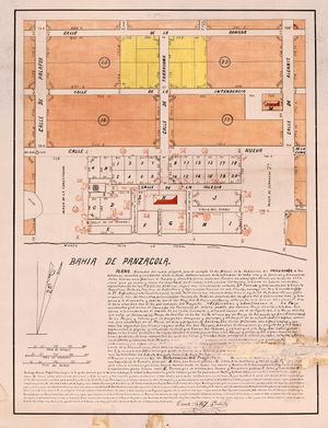
The Pintado plan is a street map drawn in 1812 by Vicente Sebastián Pintado, Surveyor General of Spanish West Florida.
The very lengthy but full title of the map is
- Borrador del nuevo proyecto para el arreglo de dos plazas en la Poblacion de Panzacola á los extremos oriental y occidental de la actual determinacion de la extension de cada una y la posicion y dimensiones de los Solares para fabricar el Templo y otros Edificios publicos.
The map depicts the street grid in the core old city of Pensacola; most of the grid and street names depicted are still intact today. Among the streets named on the Pintado plan are:
- Palafox Street (Calle de Palafox)
- Tarragona Street (Calle de Tarragona)
- Alcaniz Street (Calle de Alcaniz}
- Romana Street (Calle de Romana)
- Intendencia Street (Calle de la Intendencia)
- Government Street (Calle de Gobierno)
- Church Street (Calle de la Iglesia)
- Commendencia Street (Calle de la Commandancia)
- Barracks Street (Calle de los Quarteles)
- Brue Street and Manressa Street are depicted at the top of the map as "Bru" and "Manresa"
What is now Zaragoza Street is not contiguous on the Pintado plan, but rather split among streets labelled "Calle de la Recova" and "Calle del Tivoli de Reding". The shoreline is depicted near where present-day Main Street would be.
Confusingly, what is now Seville Square is depicted as "Plaza de Fernando 7o" (Plaza of Ferdinand VII), while the plaza to the west that currently bears that name is called "Plaza de la Constitución" (Constitution Plaza).
The map itself is held in the collections of the George A. Smathers Libraries of the University of Florida.
