Interstate 110
Jump to navigation
Jump to search

| |
| Interstate 110 | |
| North end: | Interstate 10 |
|---|---|
| Major junctions: |
Chase Street Gregory Street Garden Street Cervantes Street Maxwell Street Fairfield Drive Brent Lane |
| South end: | Downtown Pensacola |
|
<googlemap lat="30.45992" lon="-87.219086" type="map" zoom="11" width="288" height="250">
30.503339, -87.230072 30.479524, -87.23033 30.454889, -87.223635 30.453409, -87.222776 30.448304, -87.218914 30.445788, -87.217627 30.434392, -87.215395 30.431062, -87.21591 30.421662, -87.214365 30.418184, -87.212391 </googlemap> | |
Interstate 110 or I-110 is an Interstate Highway spur connecting the downtown Pensacola area with Interstate 10. Interstate 110 carries the hidden designation Florida 8A.
As of 2007, Interstate 110 is under extensive construction:
- The roadway is being widened to six lanes
- A new interchange with Interstate 10 is being constructed
- A new Airport Boulevard exit is being added
Contents
History
- 1969 – Interstate 110 constructed from Maxwell Street north to Interstate 10 (first segment to open)
- 1978 – Interstate 110 opened from Gregory St. north to Maxwell Street
Exits
- Exits 1A/1B/1C – Gregory/Chase/Garden Streets (US 98)
- Exit 2 – Cervantes Street
- Exit 3 – Maxwell Street
- Exit 4 – Fairfield Drive
- Exit 5 – Brent Lane
- (presumably) Exit 6 – Airport Boulevard (under construction)
- Note: Exits 1-3 are southbound only.
Images
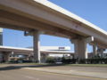
The southern terminus of Interstate 110 as seen from Wright Street.

External links
| This road-related article is a stub. You can help Pensapedia by expanding it. |