Difference between revisions of "Interstate 110"
Jump to navigation
Jump to search
m |
m (Category:Major thoroughfares is a subcat of Category:Roads) |
||
| Line 63: | Line 63: | ||
{{road-stub}} | {{road-stub}} | ||
| − | + | [[Category:Major thoroughfares]] | |
Revision as of 16:23, 14 April 2007
| |||
| Interstate 110 | |||
| North end: | Interstate 10 | ||
|---|---|---|---|
| Major junctions: |
Chase Street Gregory Street Garden Street Cervantes Street Maxwell Street Fairfield Drive Brent Lane | ||
| South end: | Downtown Pensacola | ||
|
<googlemap lat="30.45992" lon="-87.219086" type="map" zoom="11" width="288" height="250">
30.503339, -87.230072 30.479524, -87.23033 30.454889, -87.223635 30.453409, -87.222776 30.448304, -87.218914 30.445788, -87.217627 30.434392, -87.215395 30.431062, -87.21591 30.421662, -87.214365 30.418184, -87.212391 </googlemap> | |||


Interstate 110 or I-110 is an Interstate Highway spur connecting the downtown Pensacola area with Interstate 10. Interstate 110 carries the hidden designation Florida 8A.
As of 2007, Interstate 110 north of Exit 3 is under extensive construction:
- The roadway is being widened to six lanes
- A new interchange with Interstate 10 is being constructed
- A new Airport Boulevard exit is being added
Contents
History
- 1969 – Interstate 110 constructed from Maxwell Street north to Interstate 10 (first segment to open)
- 1978 – Interstate 110 opened from Gregory St. north to Maxwell Street
Exits
- Exits 1A/1B/1C – Gregory/Chase/Garden Streets (US 98)
- Exit 2 – Cervantes Street
- Exit 3 – Maxwell Street
- Exit 4 – Fairfield Drive
- Exit 5 – Brent Lane
- (presumably) Exit 6 – Airport Boulevard (under construction)
- Note: Exits 1-3 are southbound only.
Images
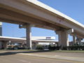
The southern terminus of Interstate 110 as seen from Wright Street.

External links
| This road-related article is a stub. You can help Pensapedia by expanding it. |