Portal:History/Selected picture
Jump to navigation
Jump to search
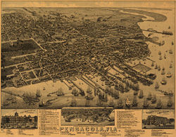

The Wellge map is an aerial rendering of Pensacola created in 1885 by Henry Wellge. The extremely detailed lithograph is a bird's eye perspective of downtown Pensacola, then a bustling port city.