Difference between revisions of "Portal:History/Selected picture"
Jump to navigation
Jump to search
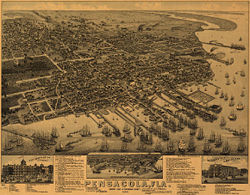
(New page: 250px|left|Overview of the Wellge map The '''Wellge map''' is an aerial rendering of Pensacola created in 1885 by Henry Wellge. The extremely detailed l...) |
(No difference)
|
Revision as of 12:54, 3 September 2007

The Wellge map is an aerial rendering of Pensacola created in 1885 by Henry Wellge. The extremely detailed lithograph is a bird's eye perspective of downtown Pensacola, then a bustling port city. A legend, directory and numbered points of interest line the bottom, along with inset illustrations of three locations: the New Continental Hotel, the Navy Yards and the Merchants' Hotel.