Difference between revisions of "Interstate 110"
m (Category:Major thoroughfares is a subcat of Category:Roads) |
(Totally not worth copying all those templates. More info later.) |
||
| Line 34: | Line 34: | ||
</googlemap> | </googlemap> | ||
}} | }} | ||
| − | '''Interstate 110''' | + | '''Interstate 110''' (I-110) is a {{convert|6.34|mi|km|adj=on}} auxiliary route of the Interstate Highway System in Pensacola, running north from [[U.S. Highway 98]] to [[Interstate 10]]. I-110 carries the hidden [[Wikipedia:Florida Department of Transportation|Florida Department of Transportation]] designation of '''State Road 8A'''. It is also known as the '''[[Reubin O'Donovan Askew]] Parkway''', in honor of the former governor of Florida who is also a Pensacola native. |
| − | + | ==Route description== | |
| − | + | Since its completion, Interstate 110 has consisted of six interchanges. At the south end is Exit 1, a directional T interchange that connects the freeway with [[Garden Street|Garden]], [[Chase Street|Chase]] and [[Gregory Street]]s. Exit 2 links I-110 to [[U.S. Highway 90]]/[[U.S. Highway 98|98]], also known as [[Cervantes Street]]. There are only southbound exit and northbound entrance ramps at this interchange. This same ramp configuration can be found just to the north at Exit 3: [[Maxwell Street|Maxwell]] and [[Jordan Street]]s. | |
| − | + | ||
| − | + | Past Exit 3, where the elevated freeway returns to ground level, there are two diamond interchanges. The first is Exit 4: To [[Fairfield Drive]] (State Road 295]]). The northbound ramps at Exit 4 have been moved entirely to the southeast quadrant of the intersection and directly connect to [[Davis Highway]] ([[State Road 291]]) just south of Fairfield Drive. Just north of that point is Exit 5: [[Brent Lane]] ([[State Road 296]]), [[Airport Boulevard]]. Directly adjacent to the southbound lanes approaching the Brent Lane exit is [[Pensacola Christian College]], a major destination for much of the traffic in that area. Originally, north of Exit 5 was an overpass for [[State Road 742]] along [[Burgess Road]]. However, between 2004 and 2006, S.R. 742 was rerouted along a new wider overpass at [[Creighton Road]] and the old Burgess Road overpass was demolished. | |
| + | |||
| + | Interstate 110's northern terminus is at [[Interstate 10]]. There is a combination [[Wikipedia:trumpet interchange|trumpet]]-[[Wikipedia:Interchange (road)#Between two freeways|directional T]] interchange at this location that is in close proximity to the I-10 interchange with Davis Highway to the east. | ||
==History== | ==History== | ||
| − | + | The portion of I-110 north of Maxwell Street was completed in [[1969]] as a four-lane, at-grade freeway. In [[1978]], the portion from Maxwell Street south to its current terminus at Garden and Chase Streets was opened to traffic. This portion is a four-lane, elevated freeway for its entire length. | |
| − | + | ||
| + | Construction of the elevated portion of Interstate 110 caused controversy in that it threatened several historic landmarks. The freeway eliminated over 30 blocks of dense existing development including the popular [[Dairy Bar]] ice cream shop and a centuries-old [[live oak]]. A portion of the freeway also directly abuts [[St. Michael's Cemetery]], which houses graves as old as the 1700s. | ||
| + | |||
| + | Between 2004 and 2009, Interstate 110 was fully rebuilt and expanded to six lanes from Interstate 10 south to Maxwell Street. Reconstruction of the freeway also added access to and from Airport Boulevard via a modification of the existing Brent Lane interchange.<ref>{{cite web |url=http://www.i10-i110.com/description.htm |title=FDOT Escambia County Transportation Improvement Projects-Project Descriptions|accessdate=July 7, 2007 |author=Florida Department of Transportation}}</ref> | ||
| + | |||
| + | ==Future== | ||
| + | Plans to extend Interstate 110 north from Interstate 10 to [[U.S. Highway 90 Alternate]] ([[Nine Mile Road]]), and possibly even as far as [[Interstate 65]] in southwestern Alabama, were discussed in the 1990s.<ref>Florida Department of Transportation. "I-10 to I-65 Corridor Study". Tallahassee, Florida, 1993.</ref> Political and financial hurdles, however, have stalled serious consideration of the project.<ref>Barnes, Brad, and Charles Ashby. "I-65 link is 'dead in the water'". ''Pensacola News Journal'', Pensacola, Florida, May 26, 1995.</ref> | ||
| + | |||
| + | ==Exit list== | ||
| + | {|class=wikitable | ||
| + | !Mile<ref name="Interchange">{{cite web |url=http://www.dot.state.fl.us/planning/statistics/pdfs/interchange.pdf |format=PDF|title=FDOT Interchange Report |accessdate=July 7, 2007 |author=Florida Department of Transportation}}</ref> | ||
| + | !# | ||
| + | !Destinations | ||
| + | !Notes | ||
| + | |- | ||
| + | |0.750 | ||
| + | |1 | ||
| + | |{{jct|state=FL|US|98|name1=[[Chase Street]]|US-Bus|98|dab2=Pensacola|name2=[[Garden Street]]|road=[[Gregory Street]]}} | ||
| + | |Southbound exit and northbound entrance | ||
| + | |- | ||
| + | |0.590 | ||
| + | |2 | ||
| + | |{{jct|state=FL|US|90|US|98|name2=[[Cervantes Street]]}} | ||
| + | |Southbound exit and northbound entrance | ||
| + | |- | ||
| + | |1.590 | ||
| + | |3 | ||
| + | |[[Maxwell Street]], [[Jordan Street]] | ||
| + | |Southbound exit and northbound entrance | ||
| + | |- | ||
| + | |2.691 | ||
| + | |4 | ||
| + | |{{jct|state=FL|FL|295|name1=[[Fairfield Drive]]}} | ||
| + | | | ||
| + | |- | ||
| + | |4.146 | ||
| + | |5 | ||
| + | |{{jct|state=FL|FL|296|name1=[[Brent Lane]]}}, [[Airport Boulevard]] – [[Pensacola Regional Airport]] | ||
| + | |Split diamond interchange; original standard diamond interchange connected to [[Brent Lane]] only (prior to October 2009).<ref>{{cite web |url=http://www.i10-i110.com/projects/4.htm |title=Interstate 110/Airport Boulevard Split Diamond Interchange|accessdate=July 7, 2007 |author=Florida Department of Transportation}}</ref> | ||
| + | |- | ||
| + | |6.341 | ||
| + | |6 | ||
| + | |{{jct|state=FL|I|10|city1=Tallahassee}}, [[Mobile, Alabama|Mobile]] | ||
| + | |Northbound exit and southbound entrance | ||
| + | |} | ||
| − | == | + | ==References== |
| − | + | {{reflist}} | |
| − | |||
| − | |||
| − | |||
| − | |||
| − | |||
| − | |||
==Images== | ==Images== | ||
Revision as of 21:19, 23 May 2010
| |||
| Interstate 110 | |||
| North end: | Interstate 10 | ||
|---|---|---|---|
| Major junctions: |
Chase Street Gregory Street Garden Street Cervantes Street Maxwell Street Fairfield Drive Brent Lane | ||
| South end: | Downtown Pensacola | ||
|
<googlemap lat="30.45992" lon="-87.219086" type="map" zoom="11" width="288" height="250">
30.503339, -87.230072 30.479524, -87.23033 30.454889, -87.223635 30.453409, -87.222776 30.448304, -87.218914 30.445788, -87.217627 30.434392, -87.215395 30.431062, -87.21591 30.421662, -87.214365 30.418184, -87.212391 </googlemap> | |||


Interstate 110 (I-110) is a 6.34-mile (10.20 km) auxiliary route of the Interstate Highway System in Pensacola, running north from U.S. Highway 98 to Interstate 10. I-110 carries the hidden Florida Department of Transportation designation of State Road 8A. It is also known as the Reubin O'Donovan Askew Parkway, in honor of the former governor of Florida who is also a Pensacola native.
Route description
Since its completion, Interstate 110 has consisted of six interchanges. At the south end is Exit 1, a directional T interchange that connects the freeway with Garden, Chase and Gregory Streets. Exit 2 links I-110 to U.S. Highway 90/98, also known as Cervantes Street. There are only southbound exit and northbound entrance ramps at this interchange. This same ramp configuration can be found just to the north at Exit 3: Maxwell and Jordan Streets.
Past Exit 3, where the elevated freeway returns to ground level, there are two diamond interchanges. The first is Exit 4: To Fairfield Drive (State Road 295]]). The northbound ramps at Exit 4 have been moved entirely to the southeast quadrant of the intersection and directly connect to Davis Highway (State Road 291) just south of Fairfield Drive. Just north of that point is Exit 5: Brent Lane (State Road 296), Airport Boulevard. Directly adjacent to the southbound lanes approaching the Brent Lane exit is Pensacola Christian College, a major destination for much of the traffic in that area. Originally, north of Exit 5 was an overpass for State Road 742 along Burgess Road. However, between 2004 and 2006, S.R. 742 was rerouted along a new wider overpass at Creighton Road and the old Burgess Road overpass was demolished.
Interstate 110's northern terminus is at Interstate 10. There is a combination trumpet-directional T interchange at this location that is in close proximity to the I-10 interchange with Davis Highway to the east.
History
The portion of I-110 north of Maxwell Street was completed in 1969 as a four-lane, at-grade freeway. In 1978, the portion from Maxwell Street south to its current terminus at Garden and Chase Streets was opened to traffic. This portion is a four-lane, elevated freeway for its entire length.
Construction of the elevated portion of Interstate 110 caused controversy in that it threatened several historic landmarks. The freeway eliminated over 30 blocks of dense existing development including the popular Dairy Bar ice cream shop and a centuries-old live oak. A portion of the freeway also directly abuts St. Michael's Cemetery, which houses graves as old as the 1700s.
Between 2004 and 2009, Interstate 110 was fully rebuilt and expanded to six lanes from Interstate 10 south to Maxwell Street. Reconstruction of the freeway also added access to and from Airport Boulevard via a modification of the existing Brent Lane interchange.[1]
Future
Plans to extend Interstate 110 north from Interstate 10 to U.S. Highway 90 Alternate (Nine Mile Road), and possibly even as far as Interstate 65 in southwestern Alabama, were discussed in the 1990s.[2] Political and financial hurdles, however, have stalled serious consideration of the project.[3]
Exit list
| Mile[4] | # | Destinations | Notes |
|---|---|---|---|
| 0.750 | 1 | Southbound exit and northbound entrance | |
| 0.590 | 2 | Southbound exit and northbound entrance | |
| 1.590 | 3 | Maxwell Street, Jordan Street | Southbound exit and northbound entrance |
| 2.691 | 4 | ||
| 4.146 | 5 | Split diamond interchange; original standard diamond interchange connected to Brent Lane only (prior to October 2009).[5] | |
| 6.341 | 6 | 25x20px I-10 – Tallahassee, Mobile | Northbound exit and southbound entrance |
References
- ↑ Florida Department of Transportation. FDOT Escambia County Transportation Improvement Projects-Project Descriptions. Retrieved on July 7, 2007.
- ↑ Florida Department of Transportation. "I-10 to I-65 Corridor Study". Tallahassee, Florida, 1993.
- ↑ Barnes, Brad, and Charles Ashby. "I-65 link is 'dead in the water'". Pensacola News Journal, Pensacola, Florida, May 26, 1995.
- ↑ Florida Department of Transportation. FDOT Interchange Report (PDF). Retrieved on July 7, 2007.
- ↑ Florida Department of Transportation. Interstate 110/Airport Boulevard Split Diamond Interchange. Retrieved on July 7, 2007.
Images
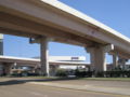
The southern terminus of Interstate 110 as seen from Wright Street.

External links
| This road-related article is a stub. You can help Pensapedia by expanding it. |