Difference between revisions of "Clubbs Block"
Jump to navigation
Jump to search
(demolition date) |
(infoboxd!) |
||
| Line 1: | Line 1: | ||
| − | + | {{Infobox Building | |
| + | |image=ClubbsBlock-MerchantsBank.jpg | ||
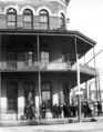
| + | |caption=The [[Merchants Bank]] & [[Turton's Photo Gallery]] in the Clubbs building | ||
| + | |name=Clubbs Block | ||
| + | |location=NE corner [[Government Street|Government]] and [[Palafox Street]]s | ||
| + | |architect= | ||
| + | |client=[[A. V. Clubbs]] | ||
| + | |engineer=[[A. V. Clubbs]] | ||
| + | |owner= | ||
| + | |construction_start_date= | ||
| + | |completion_date= | ||
| + | |renovations= | ||
| + | |date_demolished=August [[1909]] | ||
| + | |cost= | ||
| + | |structural_system= | ||
| + | |style= | ||
| + | |size=Three stories | ||
| + | |mapcode= | ||
| + | }} | ||
The '''Clubbs Block''' was a three-story building located at the northeast corner of [[Palafox Street|Palafox]] and [[Government Street]]s (where [[Seville Tower]] currently sits). Owned by builder [[A. V. Clubbs]], it was the headquarters of the [[Merchants Bank]], among other tenants, and is depicted in the [[Wellge map]] of [[1885]]. | The '''Clubbs Block''' was a three-story building located at the northeast corner of [[Palafox Street|Palafox]] and [[Government Street]]s (where [[Seville Tower]] currently sits). Owned by builder [[A. V. Clubbs]], it was the headquarters of the [[Merchants Bank]], among other tenants, and is depicted in the [[Wellge map]] of [[1885]]. | ||
Revision as of 23:13, 2 October 2008
| Clubbs Block | |
 The Merchants Bank & Turton's Photo Gallery in the Clubbs building | |
| Building Information | |
|---|---|
| Location | NE corner Government and Palafox Streets |
| Client | A. V. Clubbs |
| Engineer | A. V. Clubbs |
| Date Demolished | August 1909 |
| Size | Three stories |
The Clubbs Block was a three-story building located at the northeast corner of Palafox and Government Streets (where Seville Tower currently sits). Owned by builder A. V. Clubbs, it was the headquarters of the Merchants Bank, among other tenants, and is depicted in the Wellge map of 1885.
It was demolished in August 1908.
Other images
Circa 1906. Opera House visible in background at right.

| This architecture-related article is a stub. You can help Pensapedia by expanding it. |