Difference between revisions of "Belmont-DeVilliers"
(image) |
m |
||
| Line 9: | Line 9: | ||
30.419997, -87.225577 | 30.419997, -87.225577 | ||
</googlemap></div> | </googlemap></div> | ||
| − | The '''Belmont-DeVilliers''' district, sometimes known as '''West Hill''', is a historic neighborhood in Pensacola, centered around [[Belmont Street|Belmont]] and [[De Villiers Street|de Villiers Street]]s. Belmont-DeVilliers is historically a center of Pensacola's African-American community, due largely to Florida's "Jim Crow" laws which took effect in [[1905]]. It was a bustling commercial district in the early twentieth century, until a number of factors led to an exodus of both businesses and residents in the 1950s. | + | The '''Belmont-DeVilliers''' district, sometimes known as '''West Hill''' or "'''the Blocks'''," is a historic neighborhood in Pensacola, centered around [[Belmont Street|Belmont]] and [[De Villiers Street|de Villiers Street]]s. Belmont-DeVilliers is historically a center of Pensacola's African-American community, due largely to Florida's "Jim Crow" laws which took effect in [[1905]]. It was a bustling commercial district in the early twentieth century, until a number of factors led to an exodus of both businesses and residents in the 1950s. |
The Belmont-DeVilliers Neighbourhood Association defines the district as bordered by [[Cervantes Street]] to the north, [[Gregory Street]] to the south, [[A Street]] to the west, and [[Spring Street]] to the east.<ref>[http://www.ci.pensacola.fl.us/upload/PDFs/CommunityDevelopment/ResourceGuide.pdf Pensacola Neighbourhood Resource Guide 2007]</ref> The [[City of Pensacola]]'s [[Community Redevelopment Agency]] (CRA) considers the neighborhood boundaries expanded south to [[Garden Street]] and excluding that which is north of [[La Rua Street]] and east of [[Reus Street]]. According to the CRA, the neighborhood occupies about 35 city blocks, or roughly 100 acres.<ref>[http://www.pensacolacitygov.com/upload/images/CRA/PDFs/final%20report%20-%20part%201.pdf CRA Future Land Use Plan for Belmont-DeVilliers]</ref> | The Belmont-DeVilliers Neighbourhood Association defines the district as bordered by [[Cervantes Street]] to the north, [[Gregory Street]] to the south, [[A Street]] to the west, and [[Spring Street]] to the east.<ref>[http://www.ci.pensacola.fl.us/upload/PDFs/CommunityDevelopment/ResourceGuide.pdf Pensacola Neighbourhood Resource Guide 2007]</ref> The [[City of Pensacola]]'s [[Community Redevelopment Agency]] (CRA) considers the neighborhood boundaries expanded south to [[Garden Street]] and excluding that which is north of [[La Rua Street]] and east of [[Reus Street]]. According to the CRA, the neighborhood occupies about 35 city blocks, or roughly 100 acres.<ref>[http://www.pensacolacitygov.com/upload/images/CRA/PDFs/final%20report%20-%20part%201.pdf CRA Future Land Use Plan for Belmont-DeVilliers]</ref> | ||
| Line 15: | Line 15: | ||
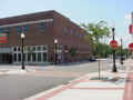
The CRA initiated a revitalization project called the "Future Land Use Plan" that installed new sidewalks, brick crosswalks, historic streetlamps and landscaping to the area's four-block core. The project has also set guidelines for future residential and commercial development that will preserve the historic flavor of the neighborhood while promoting growth.<ref>http://www.ci.pensacola.fl.us/live/pages.asp?pageID=2065</ref> | The CRA initiated a revitalization project called the "Future Land Use Plan" that installed new sidewalks, brick crosswalks, historic streetlamps and landscaping to the area's four-block core. The project has also set guidelines for future residential and commercial development that will preserve the historic flavor of the neighborhood while promoting growth.<ref>http://www.ci.pensacola.fl.us/live/pages.asp?pageID=2065</ref> | ||
| − | The district | + | The district hosts the annual [[Goombay]] festival. |
==Demographics== | ==Demographics== | ||
Revision as of 15:58, 12 June 2008
- 758BC5 (#AEBAD8)
30.419997, -87.225587 30.420016, -87.225201 30.420858, -87.220083 30.414973, -87.218753 30.41378, -87.225652 30.413789, -87.225941 30.419997, -87.225577
</googlemap>The Belmont-DeVilliers district, sometimes known as West Hill or "the Blocks," is a historic neighborhood in Pensacola, centered around Belmont and de Villiers Streets. Belmont-DeVilliers is historically a center of Pensacola's African-American community, due largely to Florida's "Jim Crow" laws which took effect in 1905. It was a bustling commercial district in the early twentieth century, until a number of factors led to an exodus of both businesses and residents in the 1950s.
The Belmont-DeVilliers Neighbourhood Association defines the district as bordered by Cervantes Street to the north, Gregory Street to the south, A Street to the west, and Spring Street to the east.[1] The City of Pensacola's Community Redevelopment Agency (CRA) considers the neighborhood boundaries expanded south to Garden Street and excluding that which is north of La Rua Street and east of Reus Street. According to the CRA, the neighborhood occupies about 35 city blocks, or roughly 100 acres.[2]
The CRA initiated a revitalization project called the "Future Land Use Plan" that installed new sidewalks, brick crosswalks, historic streetlamps and landscaping to the area's four-block core. The project has also set guidelines for future residential and commercial development that will preserve the historic flavor of the neighborhood while promoting growth.[3]
The district hosts the annual Goombay festival.
Demographics
As of 2004, the neighborhood was roughly 67% black, 30% white, and 3% various other ethnicities. 25% of the population was 65 years of age or older, with 12% between the ages of 50-64, 16% aged 40-49, 11% aged 30-39, 10% aged 22-29, 3% aged 18-21, 17% aged 5-17, and 6% under the age of five. The Belmont-DeVillers neighborhood has higher percentages of both black residents and residents over the age of 65 than does the City at large, which has a 31% black population and a 17.2% 65+ population, respectively.[4]
Landmarks
Other images
Redesigned streetscape


References
| This community-related article is a stub. You can help Pensapedia by expanding it. |