
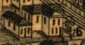
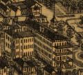
The Wellge map is an aerial rendering of Pensacola created in 1885 by Henry Wellge. The extremely detailed lithograph is a bird's eye perspective of downtown Pensacola, then a bustling port city.
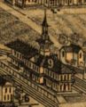
A legend, directory and numbered points of interest line the bottom, along with inset illustrations of three locations: the New Continental Hotel, the Navy Yards and the Merchants' Hotel.
The map was published by Norris, Wellge & Co. of Milwaukee, Wisconsin. Wellge toured across the continent and created similar renderings for more than 150 cities.
Contents
Details
- See also the high-resolution version.
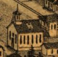
H. Colored Methodist [Church]
6. School House
9. L. & N. and P. & A. R. R. Passenger Depot
17. New Contintental Hotel, D. K. Hickey, prop. also proprietor. of the Chautauqua Hotel Lake, De Funiak, 80 Miles East of Pensacola.


Points of interest
(Transcribed as written)
| B Baptist. | ||||
| D Presbyterian. | ||||
| E Episcopal. | ||||
| G Colored Baptist. | ||||
| 2 U.S. Custom House, Court House and Post Office. | ||||
| 4 County Jail. | ||||
| 5 Opera House. | ||||
| 7 Marine Hospital. | ||||
| 8 Osceola Club Building. | ||||
| 10 Round House and Shops. | ||||
| 12 Gulf Ice Co.'s Ice Mfg. | ||||
| 13 Clubb's Block, A. V. Clubb's. | ||||
| ||||
| ||||
| 16 Brents Bank, F. C. Brent. | ||||
| 18 Merchants Hotel. M. Kryger, Prop. | ||||
| 19 City Hotel, Ed. Sexauer, Prop. | ||||
| 20 Commercial Hotel. | ||||
| 21 Carriage Manufactory, Harvey & Hilliard. | ||||
| 22 Lumber and Timber Mill, Geo. W. Wright. | ||||
| 23 Planing Mill, Sash, Doors and Blind Mfg.C.H.Overman & Co | ||||
| 24 Pensacola Foundry, J. Cosgrove. | ||||
| 25 Golay Mills M. F. Gonzalez. | ||||
| 26 Livery Feed & Sale Stable, J. B. Robert's & Son. |
Directory
| This section is a stub. You can help by expanding it. |
Notes
| This section is a stub. You can help by expanding it. |