Difference between revisions of "New City"
(New page: thumb|right|300px|1836 plat of New City development '''New City''' was the name of an 1830s development that was planned for the area east of the contemporaneous ...) |
|||
| Line 1: | Line 1: | ||
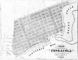
[[Image:NewCityPlat.jpg|thumb|right|300px|1836 plat of New City development]] | [[Image:NewCityPlat.jpg|thumb|right|300px|1836 plat of New City development]] | ||
| − | '''New City''' was the name of an 1830s development that was planned for the area east of the contemporaneous [[Pensacola city limits|city limits]] to [[Bayou Texar]]. | + | '''New City''' was the name of an 1830s development that was planned for the area east of the contemporaneous [[Pensacola city limits|city limits]] to [[Bayou Texar]]. The development was led by engineer [[William H. Chase]], who had amassed large land holdings in the area through speculation and promoted the area through advertisements in Northern newspapers. |
| − | The plan, as depicted in an [[1836]] plat by [[ | + | The plan, as depicted in an [[1836]] plat by [[George Edmund Chase]], William Chase's brother, called for 117 full city blocks with 30 residential lots each, plus several other partial blocks. Six additional blocks were allocated for public parks named America Square, Columbus Square, Jackson Square, Cabot Square, Galvez Square and Leon Square. |
| − | Promoted by the '''New City Company''', the development ultimately fell through. The land later became the neighborhoods of [[Hawkshaw]] and [[East Hill]]. | + | Promoted by the '''New City Company''', the development ultimately fell through after the [[Wikipedia:Panic of 1837|Panic of 1837]]. The land later became the neighborhoods of [[Hawkshaw]] and [[East Hill]]. |
{{hist-stub}} | {{hist-stub}} | ||
| + | |||
| + | [[Category:Abandoned developments]] | ||
Latest revision as of 16:27, 9 January 2009
New City was the name of an 1830s development that was planned for the area east of the contemporaneous city limits to Bayou Texar. The development was led by engineer William H. Chase, who had amassed large land holdings in the area through speculation and promoted the area through advertisements in Northern newspapers.
The plan, as depicted in an 1836 plat by George Edmund Chase, William Chase's brother, called for 117 full city blocks with 30 residential lots each, plus several other partial blocks. Six additional blocks were allocated for public parks named America Square, Columbus Square, Jackson Square, Cabot Square, Galvez Square and Leon Square.
Promoted by the New City Company, the development ultimately fell through after the Panic of 1837. The land later became the neighborhoods of Hawkshaw and East Hill.
