Difference between revisions of "Gage Hill"
Jump to navigation
Jump to search
| Line 1: | Line 1: | ||
| − | [[Image:GageHillAerial.jpg|thumb|right|Gage Hill circa 1870s]] | + | [[Image:GageHillAerial.jpg|thumb|right|The ruins of [[Fort George]] atop Gage Hill circa 1870s]] |
| − | '''Gage Hill''' is a topographical feature in central Pensacola. It is the eponymous hill of the [[North Hill]] neighborhood, its highest point located roughly at the intersection of [[Cervantes Street|Cervantes]] and [[Palafox Street]]s. It was named for British General [[Wikipedia:Thomas Gage|Thomas Gage]]. | + | '''Gage Hill''' is a topographical feature in central Pensacola. It is the eponymous hill of the [[North Hill]] neighborhood, its highest point located roughly at the intersection of [[Cervantes Street|Cervantes]] and [[Palafox Street]]s. It was named for British General [[Wikipedia:Thomas Gage|Thomas Gage]]. It was renamed '''Mount Miguel''' by the Spanish after [[1781]] and is also known as '''Palafox Hill'''. |
[[Fort George]] was built atop the hill for its strategic advantage. It is now home to [[Lee Square]]. | [[Fort George]] was built atop the hill for its strategic advantage. It is now home to [[Lee Square]]. | ||
Revision as of 18:56, 17 June 2008

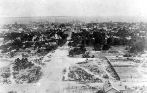
The ruins of Fort George atop Gage Hill circa 1870s
Gage Hill is a topographical feature in central Pensacola. It is the eponymous hill of the North Hill neighborhood, its highest point located roughly at the intersection of Cervantes and Palafox Streets. It was named for British General Thomas Gage. It was renamed Mount Miguel by the Spanish after 1781 and is also known as Palafox Hill.
Fort George was built atop the hill for its strategic advantage. It is now home to Lee Square.
| This geography-related article is a stub. You can help Pensapedia by expanding it. |