Difference between revisions of "East Pensacola Heights"
(New page: <div style="float:right; border-left: 20px solid #fff;"><googlemap lat="30.43084" lon="-87.18029" zoom="14" width="300" height="400"> #758BC5 (#C3DDE9) 30.436816, -87.183208 30.437056, -87...) |
(+ image) |
||
| (6 intermediate revisions by 2 users not shown) | |||
| Line 1: | Line 1: | ||
| − | <div style="float:right; border-left: 20px solid #fff;"><googlemap lat="30. | + | <div style="float:right; border-left: 20px solid #fff;"><googlemap version="0.9" lat="30.430692" lon="-87.179346" zoom="14" width="300" height="350"> |
| − | # | + | 3#FFF80824 (#33FF000C) |
| − | + | 30.439683, -87.173209 | |
| − | + | 30.439813, -87.175806 | |
| − | + | 30.439665, -87.177908 | |
| − | 30.439683, -87. | + | 30.439979, -87.182028 |
| − | 30. | + | 30.437038, -87.182329 |
| − | 30.439665, -87. | + | 30.43676, -87.183208 |
| − | 30. | + | 30.435613, -87.183058 |
| − | 30. | + | 30.435446, -87.18293 |
| − | 30. | + | 30.434429, -87.182586 |
| − | 30. | + | 30.433522, -87.182693 |
| − | 30. | + | 30.432597, -87.183037 |
| − | 30. | + | 30.43195, -87.183509 |
| − | 30. | + | 30.430969, -87.184989 |
| − | 30. | + | 30.430729, -87.186041 |
| − | 30. | + | 30.430414, -87.186835 |
| − | 30. | + | 30.429878, -87.186856 |
| − | 30. | + | 30.429804, -87.187736 |
| − | 30. | + | 30.42923, -87.188315 |
| − | 30. | + | 30.428786, -87.18823 |
| − | 30. | + | 30.428619, -87.187757 |
| − | 30. | + | 30.427879, -87.187006 |
| − | 30. | + | 30.427565, -87.187006 |
| − | 30. | + | 30.427435, -87.186663 |
| − | 30. | + | 30.427158, -87.186577 |
| − | 30. | + | 30.426899, -87.186599 |
| − | 30. | + | 30.426954, -87.186384 |
| − | 30. | + | 30.426307, -87.186556 |
| − | 30. | + | 30.4259, -87.187092 |
| − | 30. | + | 30.425548, -87.187371 |
| − | 30. | + | 30.425122, -87.186856 |
| − | 30. | + | 30.424715, -87.18662 |
| − | 30. | + | 30.424567, -87.18662 |
| − | 30. | + | 30.424419, -87.186427 |
| − | 30. | + | 30.423975, -87.185955 |
| − | 30. | + | 30.423402, -87.185783 |
| − | 30. | + | 30.422884, -87.186041 |
| − | 30. | + | 30.422643, -87.185977 |
| − | 30. | + | 30.422366, -87.185869 |
| − | 30. | + | 30.421607, -87.186363 |
| − | 30. | + | 30.421551, -87.186921 |
| − | 30. | + | 30.420922, -87.187006 |
| − | 30. | + | 30.421163, -87.183681 |
| − | 30. | + | 30.421329, -87.182393 |
| − | 30. | + | 30.421625, -87.181385 |
| − | 30. | + | 30.421958, -87.180355 |
| − | 30. | + | 30.422995, -87.179217 |
| − | 30. | + | 30.423661, -87.178595 |
| − | 30. | + | 30.425456, -87.176943 |
| − | 30. | + | 30.426862, -87.175891 |
| − | 30. | + | 30.428767, -87.174561 |
| − | 30. | + | 30.430414, -87.17396 |
| − | 30. | + | 30.431765, -87.173467 |
| − | 30. | + | 30.434984, -87.173038 |
| − | 30. | ||
| − | 30. | ||
| − | |||
| − | |||
| − | |||
| − | |||
| − | |||
| − | |||
| − | |||
| − | |||
| − | |||
| − | |||
| − | |||
| − | |||
| − | |||
| − | |||
| − | |||
| − | |||
| − | |||
| − | |||
| − | |||
| − | 30. | ||
</googlemap></div> | </googlemap></div> | ||
'''East Pensacola Heights''' is a neighborhood in east Pensacola, situated between [[Bayou Texar]] and [[Pensacola Bay]], bordered on the north by [[Hyde Park Road]]. | '''East Pensacola Heights''' is a neighborhood in east Pensacola, situated between [[Bayou Texar]] and [[Pensacola Bay]], bordered on the north by [[Hyde Park Road]]. | ||
==Restaurant row== | ==Restaurant row== | ||
| − | The length of [[Cervantes Street]] in East Pensacola Heights is a "restaurant row" akin to the one on [[Gregory Street]], as it is host to a number of popular eateries: | + | The length of [[Cervantes Street]] (and the inital part of [[Scenic Highway]]) in East Pensacola Heights is a "restaurant row" akin to the one on [[Gregory Street]], as it is host to a number of popular eateries: |
*[[Mediterranean Plus]] | *[[Mediterranean Plus]] | ||
*[[Jerry's Drive-In]] | *[[Jerry's Drive-In]] | ||
| − | *[[ | + | *[[Georgio's Pizza]] |
*The [[New Yorker Deli]] | *The [[New Yorker Deli]] | ||
*[[Horizen]] | *[[Horizen]] | ||
*[[Hunan]] | *[[Hunan]] | ||
| + | *[[Cazadores Mexican Restaurant]] | ||
| + | *[[Scenic 90]] | ||
| + | *[[Skopelos]] | ||
| + | |||
| + | ==Other images== | ||
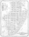
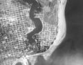
| + | <gallery> | ||
| + | Image:EastPensacolaHeightsMap.jpg|Development plat of East Pensacola Heights, circa 1940s | ||
| + | Image:EPH1941.jpg|East Pensacola Heights in 1940 | ||
| + | </gallery> | ||
[[Category:Neighborhoods]] | [[Category:Neighborhoods]] | ||
Latest revision as of 22:42, 5 April 2009
3#FFF80824 (#33FF000C) 30.439683, -87.173209 30.439813, -87.175806 30.439665, -87.177908 30.439979, -87.182028 30.437038, -87.182329 30.43676, -87.183208 30.435613, -87.183058 30.435446, -87.18293 30.434429, -87.182586 30.433522, -87.182693 30.432597, -87.183037 30.43195, -87.183509 30.430969, -87.184989 30.430729, -87.186041 30.430414, -87.186835 30.429878, -87.186856 30.429804, -87.187736 30.42923, -87.188315 30.428786, -87.18823 30.428619, -87.187757 30.427879, -87.187006 30.427565, -87.187006 30.427435, -87.186663 30.427158, -87.186577 30.426899, -87.186599 30.426954, -87.186384 30.426307, -87.186556 30.4259, -87.187092 30.425548, -87.187371 30.425122, -87.186856 30.424715, -87.18662 30.424567, -87.18662 30.424419, -87.186427 30.423975, -87.185955 30.423402, -87.185783 30.422884, -87.186041 30.422643, -87.185977 30.422366, -87.185869 30.421607, -87.186363 30.421551, -87.186921 30.420922, -87.187006 30.421163, -87.183681 30.421329, -87.182393 30.421625, -87.181385 30.421958, -87.180355 30.422995, -87.179217 30.423661, -87.178595 30.425456, -87.176943 30.426862, -87.175891 30.428767, -87.174561 30.430414, -87.17396 30.431765, -87.173467 30.434984, -87.173038
</googlemap>East Pensacola Heights is a neighborhood in east Pensacola, situated between Bayou Texar and Pensacola Bay, bordered on the north by Hyde Park Road.
Restaurant row[edit]
The length of Cervantes Street (and the inital part of Scenic Highway) in East Pensacola Heights is a "restaurant row" akin to the one on Gregory Street, as it is host to a number of popular eateries:
- Mediterranean Plus
- Jerry's Drive-In
- Georgio's Pizza
- The New Yorker Deli
- Horizen
- Hunan
- Cazadores Mexican Restaurant
- Scenic 90
- Skopelos
Other images[edit]
Development plat of East Pensacola Heights, circa 1940s
East Pensacola Heights in 1940

