Difference between revisions of "DeLuna Alley"
m (Cushman's Alley moved to DeLuna Alley) |
(images) |
||
| (6 intermediate revisions by the same user not shown) | |||
| Line 1: | Line 1: | ||
| − | + | {{Infobox road | |
| + | |marker_image= | ||
| + | |road_name=DeLuna Alley | ||
| + | |name_notes= | ||
| + | |type= | ||
| + | |route= | ||
| + | |alternate_name= | ||
| + | |maint= | ||
| + | |length_mi= | ||
| + | |length_round= | ||
| + | |length_ref= | ||
| + | |length_notes= | ||
| + | |established= | ||
| + | |decommissioned= | ||
| + | |direction_a=north | ||
| + | |starting_terminus=[[Intendencia Street]] | ||
| + | |junction= | ||
| + | |direction_b=south | ||
| + | |ending_terminus=South of [[Intendencia Street]] | ||
| + | |namesake= | ||
| + | |map= | ||
| + | |mapcode=<googlemap version="0.9" lat="30.410162" lon="-87.213882" zoom="17" width="288" height="200"> | ||
| + | 6#B2758BC5 | ||
| + | 30.410421, -87.213988 | ||
| + | 30.410139, -87.213921 | ||
| + | </googlemap> | ||
| + | }} | ||
| + | '''DeLuna Alley''' is a short, narrow City alley in [[downtown Pensacola]]. In its present form, it extends south from [[Intendencia Street]], just west of [[Jefferson Street]], for less than one block, behind [[Ragtyme Grille]]. Previously, the alley continued south and connected with [[Government Street]]. | ||
| + | ''Early Vital Records of Pensacola, Florida'' places the alley thusly: | ||
:''Located one block east of [[Palafox Street|Palafox]], between [[Government Street|Government]] and [[Intendencia Street|Intendencia]], about 100 feet west of and parallel to [[Jefferson Street|Jefferson]], which was not yet cut through.'' | :''Located one block east of [[Palafox Street|Palafox]], between [[Government Street|Government]] and [[Intendencia Street|Intendencia]], about 100 feet west of and parallel to [[Jefferson Street|Jefferson]], which was not yet cut through.'' | ||
| − | The name "Cushman's Alley" | + | ==History== |
| + | Previously called '''Cushman's Alley''' or '''De Reache Alley''', it was established as a City street, called '''DeLuna Street''', by ordinance in [[1906]]: | ||
| + | {{cquote|''The thoroughfare ... now known as Cushman's Alley or Dereache Street, is hereby declared to be a street to be known as DeLuna Street, and the City hereby assumes full control of and obligations for the maintenance and use of the same as a street.|20px|20px|Legal notice, ''Pensacola Journal'', March 31, 1906.}} | ||
| + | |||
| + | Upon its establishment as as a city street in 1906, the street was 15½ to 16½ feet wide and permitted only one-way southbound traffic. Upon assuming ownership of the street, the City agreed not to construct sidewalks or allow the erection of utility poles on the street.<ref>Legal notice, ''Pensacola Journal'', March 31, 1906.</ref> | ||
| + | |||
| + | The name "Cushman's Alley" was derived from [[Cushman's Drug Store]].<ref>''Early Vital Records of Pensacola, Florida''. West Florida Genealogical Society (1989). Sidney P. Thomes, Editor.</ref> | ||
| + | |||
| + | The alley is depicted, but not labelled, on the [[Sanborn Maps#1884|1884]] and [[Sanborn Maps#1892|1892 Sanborn Maps]], and depicted and labelled "De Reache St." on the [[Sanborn Maps#1903|1903 Sanborn Maps]]. | ||
| + | |||
| + | ==Images== | ||
| + | <gallery> | ||
| + | Image:Deluna-1896-koch.jpg|DeReache/Cushman's Alley, 1896 | ||
| + | Image:JournalBuilding.PNG|DeLuna Street and [[Journal Building]], 1906 | ||
| + | Image:Bedlam-TopOfTheTown-15East.jpg|DeLuna Alley and Bedlam ([[Journal Building]]), 2007 | ||
| + | </gallery> | ||
==References== | ==References== | ||
| Line 9: | Line 52: | ||
{{stub}} | {{stub}} | ||
| + | [[Category:Roads]] | ||
Latest revision as of 23:18, 6 December 2009
| DeLuna Alley | |
| north end: | Intendencia Street |
|---|---|
| south end: | South of Intendencia Street |
|
<googlemap version="0.9" lat="30.410162" lon="-87.213882" zoom="17" width="288" height="200"> 6#B2758BC5 30.410421, -87.213988 30.410139, -87.213921 </googlemap> | |
DeLuna Alley is a short, narrow City alley in downtown Pensacola. In its present form, it extends south from Intendencia Street, just west of Jefferson Street, for less than one block, behind Ragtyme Grille. Previously, the alley continued south and connected with Government Street.
Early Vital Records of Pensacola, Florida places the alley thusly:
- Located one block east of Palafox, between Government and Intendencia, about 100 feet west of and parallel to Jefferson, which was not yet cut through.
History[edit]
Previously called Cushman's Alley or De Reache Alley, it was established as a City street, called DeLuna Street, by ordinance in 1906:
| The thoroughfare ... now known as Cushman's Alley or Dereache Street, is hereby declared to be a street to be known as DeLuna Street, and the City hereby assumes full control of and obligations for the maintenance and use of the same as a street. | ||
—Legal notice, Pensacola Journal, March 31, 1906. | ||
Upon its establishment as as a city street in 1906, the street was 15½ to 16½ feet wide and permitted only one-way southbound traffic. Upon assuming ownership of the street, the City agreed not to construct sidewalks or allow the erection of utility poles on the street.[1]
The name "Cushman's Alley" was derived from Cushman's Drug Store.[2]
The alley is depicted, but not labelled, on the 1884 and 1892 Sanborn Maps, and depicted and labelled "De Reache St." on the 1903 Sanborn Maps.
Images[edit]
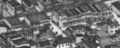
DeReache/Cushman's Alley, 1896
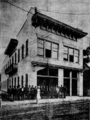
DeLuna Street and Journal Building, 1906
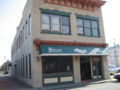
DeLuna Alley and Bedlam (Journal Building), 2007

