East Pensacola Heights
3#FFF80824 (#33FF000C) 30.439683, -87.173209 30.439813, -87.175806 30.439665, -87.177908 30.439979, -87.182028 30.437038, -87.182329 30.43676, -87.183208 30.435613, -87.183058 30.435446, -87.18293 30.434429, -87.182586 30.433522, -87.182693 30.432597, -87.183037 30.43195, -87.183509 30.430969, -87.184989 30.430729, -87.186041 30.430414, -87.186835 30.429878, -87.186856 30.429804, -87.187736 30.42923, -87.188315 30.428786, -87.18823 30.428619, -87.187757 30.427879, -87.187006 30.427565, -87.187006 30.427435, -87.186663 30.427158, -87.186577 30.426899, -87.186599 30.426954, -87.186384 30.426307, -87.186556 30.4259, -87.187092 30.425548, -87.187371 30.425122, -87.186856 30.424715, -87.18662 30.424567, -87.18662 30.424419, -87.186427 30.423975, -87.185955 30.423402, -87.185783 30.422884, -87.186041 30.422643, -87.185977 30.422366, -87.185869 30.421607, -87.186363 30.421551, -87.186921 30.420922, -87.187006 30.421163, -87.183681 30.421329, -87.182393 30.421625, -87.181385 30.421958, -87.180355 30.422995, -87.179217 30.423661, -87.178595 30.425456, -87.176943 30.426862, -87.175891 30.428767, -87.174561 30.430414, -87.17396 30.431765, -87.173467 30.434984, -87.173038
</googlemap>East Pensacola Heights is a neighborhood in east Pensacola, situated between Bayou Texar and Pensacola Bay, bordered on the north by Hyde Park Road.
Restaurant row
The length of Cervantes Street (and the inital part of Scenic Highway) in East Pensacola Heights is a "restaurant row" akin to the one on Gregory Street, as it is host to a number of popular eateries:
- Mediterranean Plus
- Jerry's Drive-In
- Georgio's Pizza
- The New Yorker Deli
- Horizen
- Hunan
- Cazadores Mexican Restaurant
- Scenic 90
- Skopelos
Other images
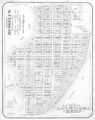
Development plat of East Pensacola Heights, circa 1940s
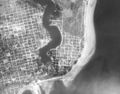
East Pensacola Heights in 1940

