File:JacobWeissCivilWarMap.jpg
Revision as of 04:41, 21 April 2007 by Admin (talk | contribs) (A correct map of Pensacola Bay showing topography of the coast, Fort Pickens, U.S. Navy Yard, and all other fortifications from the latest Government surveys. J. Weiss lith. CREATED/PUBLISHED Philadelphia, Jacob Weiss, [186-] {{PD-US}} Source: [http://m)

Size of this preview: 800 × 573 pixels. Other resolutions: 320 × 229 pixels | 1,605 × 1,150 pixels.
Original file (1,605 × 1,150 pixels, file size: 617 KB, MIME type: image/jpeg)
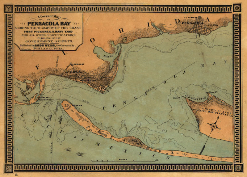
A correct map of Pensacola Bay showing topography of the coast, Fort Pickens, U.S. Navy Yard, and all other fortifications from the latest Government surveys. J. Weiss lith.
CREATED/PUBLISHED Philadelphia, Jacob Weiss, [186-]
This image is in the public domain in the United States. In most cases, this means that it was first published in the United States prior to January 1, 1923. See Pensapedia:Public domain and Pensapedia:Copyrights for more details.
File history
Click on a date/time to view the file as it appeared at that time.
| Date/Time | Thumbnail | Dimensions | User | Comment | |
|---|---|---|---|---|---|
| current | 04:41, 21 April 2007 | | 1,605 × 1,150 (617 KB) | Admin (talk | contribs) | A correct map of Pensacola Bay showing topography of the coast, Fort Pickens, U.S. Navy Yard, and all other fortifications from the latest Government surveys. J. Weiss lith. CREATED/PUBLISHED Philadelphia, Jacob Weiss, [186-] {{PD-US}} Source: [http://m |
- You cannot overwrite this file.
File usage
The following 2 pages uses this file: