Talk:Pensacola streetcar system
Source - [1]
It's been awhile [4 years] since I researched and surveyed the old trolley lines, therefore I was unable to document a source. Zooming in on DeSoto and Gadsden on a Google Maps satellite image yields the visible ROW. -AirForceWeather
- That's awesome. Any help you could provide me in putting together a route map/overview would be amazing. dscosson ··· talk 09:28, 8 May 2008 (CDT)
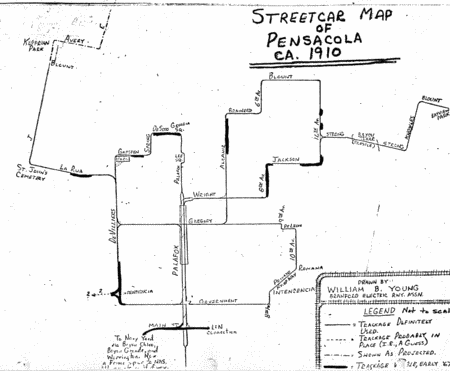
- Mr. Appleyard shared with me some of his materials on railroads and streetcars. Among them was this map. --Admin 08:46, 16 June 2008 (CDT)
Joe... you are the hero of my dreams of all of my life!!!!! THIS IS BEAUTIFUL AND HOLY!!!!!!!!!!! dscosson ··· talk 09:31, 16 June 2008 (CDT)
- Haha.... thanks? It's funny, I grew up on Strong Street near the Bayou and had no idea there used to be streetcar tracks there. (And a bridge, too!) --Admin 09:46, 16 June 2008 (CDT)
Wow! All my info was basically amateur tracking done in my free time...this map sheds a LOT of light and answers so many questions. Shame the system wasn't in some way preserved, I'm a big believer in mass transit and New Urbanism- perhaps if it had remained viable then its continued growth might've spurred more organized development rather than the unfortunate sprawl seen today.
Errors?
I'm noticing some discrepancies between the names and dates listed here and those mentioned in the official history of the Gulf Power Company. I'm inclined to trust the Gulf Power history, as the dates are more detailed, and the manuscript I got from Mr. Appleyard was just an early draft. — admin • talk 18:28, 10 August 2008 (CDT)
