Difference between revisions of "Talk:Pensacola streetcar system"
Jump to navigation
Jump to search
(add more exclamation marks) |
|||
| Line 7: | Line 7: | ||
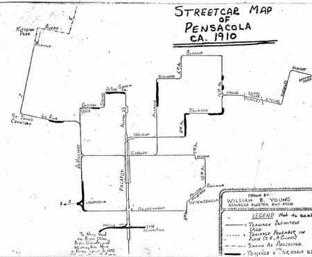
[[Image:StreetcarMap1910.gif|center|450px|Pensacola streetcar system map, circa 1910]] | [[Image:StreetcarMap1910.gif|center|450px|Pensacola streetcar system map, circa 1910]] | ||
| − | Joe... you are the hero of my dreams of all of my life!!!!! THIS IS BEAUTIFUL AND HOLY! '''[[User:Dscosson|dscosson]]''' ··· '''[[User talk:Dcosson|talk]]''' 09:31, 16 June 2008 (CDT) | + | Joe... you are the hero of my dreams of all of my life!!!!! THIS IS BEAUTIFUL AND HOLY!!!!!!!!!!! '''[[User:Dscosson|dscosson]]''' ··· '''[[User talk:Dcosson|talk]]''' 09:31, 16 June 2008 (CDT) |
Revision as of 14:34, 16 June 2008
Source - [1]
It's been awhile [4 years] since I researched and surveyed the old trolley lines, therefore I was unable to document a source. Zooming in on DeSoto and Gadsden on a Google Maps satellite image yields the visible ROW. -AirForceWeather
- That's awesome. Any help you could provide me in putting together a route map/overview would be amazing. dscosson ··· talk 09:28, 8 May 2008 (CDT)
- Mr. Appleyard shared with me some of his materials on railroads and streetcars. Among them was this map. --Admin 08:46, 16 June 2008 (CDT)

Joe... you are the hero of my dreams of all of my life!!!!! THIS IS BEAUTIFUL AND HOLY!!!!!!!!!!! dscosson ··· talk 09:31, 16 June 2008 (CDT)