Difference between revisions of "Pensacola streetcar system"
(Private research; I while living in Pensacola, I researched the old trolley lines and physically traced the routes.) |
m |
||
| Line 1: | Line 1: | ||
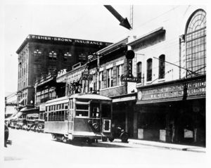
| − | [[Image:PensacolaTrolley.jpg|thumb|A trolley travels south on [[Palafox Street]]]] | + | [[Image:PensacolaTrolley.jpg|thumb|A trolley travels south on [[Palafox Street]], circa 1920s]] |
The '''Pensacola streetcar (trolley) system''' was operated by the [[Pensacola Electric Company]] in [[downtown Pensacola]] between the years [[1906]] and [[1932]]. At its peak, a total of 30 trolley cars carried four million passengers per year (1920).<ref>[http://www.dot.state.fl.us/publicinformationoffice/historicdotphotos/rail/pentrolley.htm MyFlorida.com]</ref> Routes included a line in [[Gadsden Street]] [crossing the old [[Bayou Texar]] Bridge to East Pensacola Heights] and a line to [[Kupfrian's Park]]. Also included was a loop encompassing Palafox Street, West Gadsden Street, North Spring Street, and West DeSoto Street back to Palafox, with a turnaround spur reaching on Gadsden past Spring to North [[Reus Street]]. Partially covered tracks and barely concealed right-of way are clearly visible on Gadsden [especially the turnaround track] and DeSoto Street. Another loop reached Old [[East Hill]] via [[Government Street]] to [[Alcaniz Street]] and back to Gadsden. The trolley was discontinued six years after Pensacola Electric Company's [[1932]] merger with [[Gulf Power]]. | The '''Pensacola streetcar (trolley) system''' was operated by the [[Pensacola Electric Company]] in [[downtown Pensacola]] between the years [[1906]] and [[1932]]. At its peak, a total of 30 trolley cars carried four million passengers per year (1920).<ref>[http://www.dot.state.fl.us/publicinformationoffice/historicdotphotos/rail/pentrolley.htm MyFlorida.com]</ref> Routes included a line in [[Gadsden Street]] [crossing the old [[Bayou Texar]] Bridge to East Pensacola Heights] and a line to [[Kupfrian's Park]]. Also included was a loop encompassing Palafox Street, West Gadsden Street, North Spring Street, and West DeSoto Street back to Palafox, with a turnaround spur reaching on Gadsden past Spring to North [[Reus Street]]. Partially covered tracks and barely concealed right-of way are clearly visible on Gadsden [especially the turnaround track] and DeSoto Street. Another loop reached Old [[East Hill]] via [[Government Street]] to [[Alcaniz Street]] and back to Gadsden. The trolley was discontinued six years after Pensacola Electric Company's [[1932]] merger with [[Gulf Power]]. | ||
Revision as of 15:03, 11 May 2008

The Pensacola streetcar (trolley) system was operated by the Pensacola Electric Company in downtown Pensacola between the years 1906 and 1932. At its peak, a total of 30 trolley cars carried four million passengers per year (1920).[1] Routes included a line in Gadsden Street [crossing the old Bayou Texar Bridge to East Pensacola Heights] and a line to Kupfrian's Park. Also included was a loop encompassing Palafox Street, West Gadsden Street, North Spring Street, and West DeSoto Street back to Palafox, with a turnaround spur reaching on Gadsden past Spring to North Reus Street. Partially covered tracks and barely concealed right-of way are clearly visible on Gadsden [especially the turnaround track] and DeSoto Street. Another loop reached Old East Hill via Government Street to Alcaniz Street and back to Gadsden. The trolley was discontinued six years after Pensacola Electric Company's 1932 merger with Gulf Power.